
On June 27, 2017, Governor Brown signed SB 92 into law, which set forth new requirements focused on dam safety. As part of this legislation, dam owners must now submit inundation maps to the Department of Water Resources (DWR), Division of Safety of Dams (DSOD). After the maps are approved, the dam owner must submit an Emergency Action Plan (EAP) to the Governor’s Office of Emergency Services (Cal OES). Stetson was contracted by the Irvine Ranch Water District (IRWD) to prepare inundation maps and EAPs for several of the District’s dams.
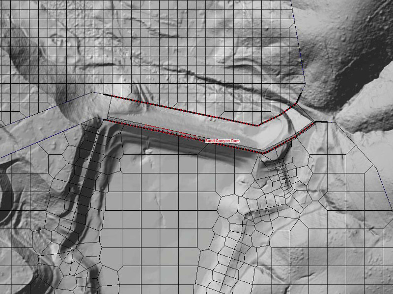
The Sand Canyon Dam is an earthen dam owned by IRWD and located in Orange County, California. This dam stores 960 acre-feet of water and was built in 1942. It is one of several key dams providing recycled water storage for this densely populated area of Orange County.
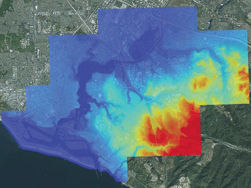
Using high resolution topographic data, Stetson’s GIS department re-projected the available data to the California Teale Albers projection in order to conform to the Department of Water Resources (DWR) regulations and developed a Digital Elevation Model (DEM) that was used in the subsequent dam failure modeling. Stetson used the Hydrologic Engineering Center River Analysis System (HEC-RAS) version 5.0.3 to simulate sunny-day failure scenarios for the dam and the critical appurtenant structures. An unsteady hydraulic model was created that was capable of performing dynamic routing to approximate the temporal and spatial changes in inundation magnitude and extent. The model was used to understand the effects of a full dam break, and simulated the depth of flooding downstream, as well as transit time. Model output was used to prepare inundation maps for several failure scenarios.
Stetson’s modeling approach and inundation maps follow guidance published in FEMA P-946: Federal Guidelines for Inundation Mapping of Flood Risks Associated with Dam Incidents and Failures and are compliant with recently published DWR Inundation Mapping Regulations. A technical memorandum was prepared that documented the modeling approach and methodology. The model results, inundation maps, and technical memorandum were submitted to the DSOD for review and approval.
Following the DSOD approval of the inundation map, Stetson is now working with the dam owner to prepare an EAP for local agency coordination and submission to Cal OES. Stetson uses the Cal OES published formatting template to produce EAPs that follow the guidance published in FEMA-64 Federal Guidelines for Dam Safety: Emergency Action Planning for Dams, and are compliant with Government Code Section 8589.5.
![]()